Teigarhorn at Berufjörður is located on the eastern edge of Iceland’s crust in the present day. The shifting of geological layers due to volcanic activity along Iceland’s active volcanic belt, where tectonic plates associated with Eurasia and North America drift apart from each other, causes the geological layers to generally slope towards the plate boundaries. The slope of the geological layers near Teigarhorn is about 2°-6° towards the interior of the country at the top of the rock sequence and about 6°-9° at the bottom of it.
The bedrock of Teigarhorn is mostly composed of lava layers that flowed during the Miocene epoch, approximately 8.5-10 million years ago. The upper part of the lavas consists of scoria lava breccia, while the core is made of dense basalt. Along the coast of Teigarhorn, one can find altered rock, which is considered to be interm. It contains a higher amount of silica than basalt and has a more viscous nature. This led to the formation of larger cavities in the rock, which were later filled with zeolites. In addition to basaltic lavas, thin layers of red sedimentary rocks are found in the land around Teigarhorn, occurring at the interfaces of some lava layers. There are also layers of tuffaceous rocks. The tuffaceous rock, which also forms Blábjörg beyond Berufjörður, is greenish and about 20 meters thick where it appears in the western Eyfreyjunesvík
A significant layer of lava has built up and lies on top of the rock now visible at Teigarhorn. It is estimated that the East fjords mountain range reached up to 1500 meters above sea level at one point. Glaciers, the sea, and other erosional forces later began to erode and shape the rock layers. The erosion and, later, glacier melting were a result of the uplift of the land. The lava layers seen at Teigarhorn have therefore been pushed deep below younger layers, and due to erosion, they are now exposed at the surface.
Running through the land of Teigarhorn is a significant swarm of dykes that cut through the lava rock sequence. According to Walker, who contributed greatly to the study of the geology of East Iceland, these dykes are believed to have originated from the Álftafjarðar volcano. There is also a substantial dyke swarm beyond Berufjörður.
In geological terms, Teigarhorn is best known for its zeolites (or geodes) found in the area. Zeolites are a category of minerals that form through the alteration and cavity-filling of rock. Their distinctive feature is that water molecules trapped within their crystal structure, 22% of their weight, are released when heated and can then be absorbed again.
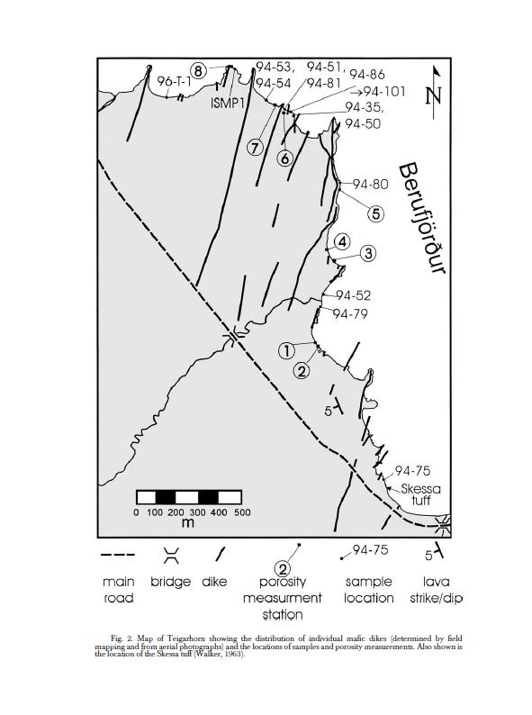
Berggangar við Teigarhorn. Philip S. Neuhoff ofl. Porosity Evolution and Mineral Paragenesis during Low-grade Metamorphism of Basaltic Lavas at Teigarhorn, East Iceland. (1999)
Minerals
There are two categories of rocks found in Iceland: primary rocks, which make up all igneous rocks, and secondary or metamorphic rocks.
Primary rocks are formed when lava solidifies. The solidification of lava is essentially the process by which different types of minerals crystallize from molten magma. These minerals include plagioclase, augite, olivine, and various metal minerals.
Secondary rocks are those that form after the solidification of magma has completed. It requires external forces or processes to create them, such as geothermal water, pressure from compression, and/or heat.
The most common types of metamorphic rocks in Iceland are carbonate and quartzites, and both of these types are found at Teigarhorn. For example, carbonate are found as silver rock in Búlandsárgljúfur and Búlandstindur, while quartzites are found as rock crystals in Ytri Gamlabæjarfjara. In addition to these two categories of metamorphic rocks, Teigarhorn also contains claystones and zeolites.
The formation of metamorphic rocks at Teigarhorn is classified into three stages:
Stage 1 – Surface Weathering and Alteration:
As soon as lava reaches the Earth’s surface, weathering begins. Minerals in the rock react with external substances, leading to the dissolution of chemical compounds, which then precipitate elsewhere. In the case of Teigarhorn, this mostly results in the formation of quartz and celadonite. The latter is a clay mineral that often lines the walls of cavities, such as gas bubbles, in rocks and is characterized by its greenish color. Quartz found at Teigarhorn consists mainly of quartz and chalcedony.
Stage 2 – Alteration Due to Heat and Pressure Below Ground:
The lavas seen in the coastal cliffs at Teigarhorn were originally located much deeper in the Earth’s crust, due to the thickness of the stratigraphic sequence that carried them, before glaciers and other erosional processes began to expose them. Due to the pressure in the Earth’s crust and the presence of water circulating through the rock, olivine (a primary mineral) and basaltic glassy minerals dissolve and precipitate as chlorite and smectite (clay minerals). Under greater pressure and at temperatures around 90°C +/- 10°C, primary minerals began to dissolve, and zeolites formed in cavities and pore spaces. The British geologist George P.L. Walker studied zeolites and other cavity-fillings in East Iceland during the 6th and 7th decades of the last century and mapped their distribution. Walker demonstrated that different types of zeolites arrange themselves into what are essentially horizontal bands, not following the dip of the rock layers, which is determined by depth (i.e., temperature and pressure). Thus, zeolites indicate the original height of the rock layer above them.
Two zeolite belts are present in the rock at Teigarhorn: the mesolite – scolecite belt and the heulandite – stilbite belt.
Stage 3 – Formation of Minerals from Hydrothermal Fluids Due to the Formation of Dykes:
The third stage of metamorphism at Teigarhorn is due to the formation of dykes from the Álftafjarðar volcano. These dykes cut through the rock sequence that was previously present and created the dyke swarm mentioned earlier. As a result, the surrounding rock was heated, and further alteration occurred. Minerals dissolved and precipitated, forming new minerals, including unique varieties of quartz, calcite (silfurberg), stilbite, scolecite, heulandite, and laumontite.
Zeolites – Geodes:
There are a total of 48 types of zeolites in the world, with 20 of them being known in Iceland. Zeolites are often categorized by their shape, whether they are radiating, blade-like, or cubical. Scolecite is an example of zeolites with radiating crystals, heulandite is an example of plate-like crystals, and chabazite is an example of cubical crystals. Due to these different shapes, some argue that the term „geodes“ is a misnomer because only one group of zeolites has radiating crystals.
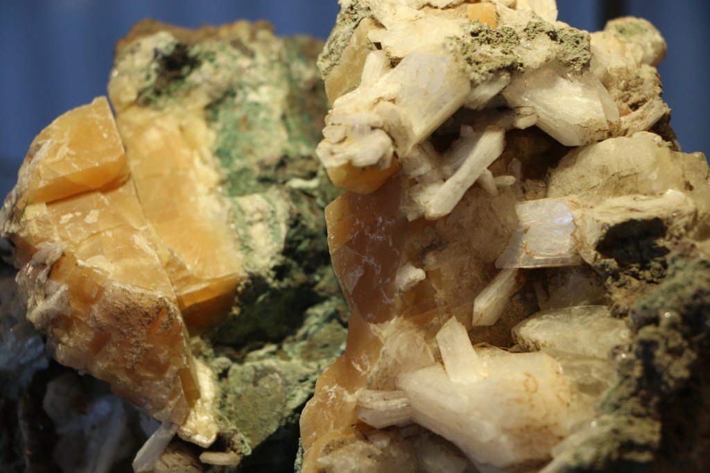
Stilbite and sugercalsite from Teigarhorn colection
As previously mentioned, water readily escapes from the crystal lattice of zeolite minerals upon heating and seems to „boil“ due to this property, hence their name. The term „zeolite“ comes from Greek, where „zeo“ (ζέω) means „to boil,“ and „lithos“ (λίθος) means „stone.“
At Teigarhorn, various types of zeolites can be found. In 1917, a Danish mineralogist described a sample from Teigarhorn, believing he had discovered a new zeolite and named flokite after Hrafna-flóki how was a Norwegian Viking who was among the first to settle in Iceland and is said to have given Iceland its name. Later, it was revealed that this sample was, in fact, mordenite.
The following zeolites are most commonly found at Teigarhorn:
Scolecite: Radiating crystals, forming long white or translucent needles, often in bundles. The typical length of these crystals is 1-2 cm, with a width of a few mm. The longest crystal found at Teigarhorn was about 9 cm. and the larges examples of scolecite in the world come from Iceland.
Heulandite: Blade-like, forming thin flat crystals. They can be single distinct crystals in cavities or grow together in clusters. They can have a pinkish color. The size of heulandite crystals generally ranges from 0.5-1 cm, but they can reach up to 10 cm in length.
Stilbite: Blade-like, similar to heulandite but white and usually forming clusters of crystals. The typical size is 1-1.5 cm, but they can reach up to 6 cm and are often found in association with heulandite.
Epistilbite: Blade-like, forming thin crystals that resemble heulandite but are elongated. They do not typically exceed 1 cm in length.
Mordenite: Radiating, appearing white or brownish with finer threads than mesolite, forming cotton-like wads or tufts. Needle size is generally about 0.5 cm.
Laumontite: Radiating, snow-white, broad stems that usually grow irregularly, but sometimes in bundles. Length is generally around 0.5 cm and is often found with calcite.
Additionally, natrolite, mesolite, clinoptilolite, stellerite, barrerite, chabazite, analcime, and gismondine have been mentioned in reports and records as having been found in the Teigarhorn area.
Glaciation
As mentioned earlier, erosional forces, primarily glaciers, have sculpted the thick stratigraphic sequence of East Iceland, creating valleys and fjords. Signs of glacial activity and their landforms can be seen in glacial terraces found inside Berufjörður. In the land of Teigarhorn, specifically on Teigartangi, one can find ice-molded and glacially scratched rocks resting on soft marine clay with shell fragments. Trausti Einarsson suggests that the glacier that descended into Berufjörður during the late Ice Age did not extend farther than this point. However, Guðmundur Kjartansson disagrees and points to signs of glacier activity on Háls, at an elevation of about 100 m, just above Teigarhorn. Trausti believes that these signs indicate the presence of a local glacier in Búlandsdal, and the direction of glacial scratches on Háls could be due to the Berufjarðarjökull glacier pushing Búlandsdalsjökull glacier into Hamarsfjörður.
Further research suggests that the extent of glaciers in the Berufjarður area may have been smaller than previously thought, with measurements of the Ice Age shoreline, which now lies at an elevation of about 58 m above sea level, providing supporting evidence.

Ummerki jöklunar í Berufirði og Breiðdal. Hreggviður Norðdahl og Þorleifur Einarsson, Concurrent changes of relative sea-level and glacier extent at the Weichselian-Holocene boundary in Berufjörður, Eastern Iceland. (2001)
Before the last Ice Age, glaciers indeed extended far beyond this area, but due to marine and freshwater erosion, most of these glacial features have disappeared. Marine erosion has resulted in the creation of a rugged coastal landscape with rocky outcrops in various places.
Tephra Layers
There haven’t been many studies on tephra layers from Teigarhorn, but due to research in Gautavík, two comparative samples were taken from Teigarhorn. Ash from the Öræfajökull eruption in 1362 was found at a depth of 25 cm in one sample and 37 cm in the other. The former tephra layer was 2.5 cm thick, while the latter was 1.8 cm thick.
Conclusion: Geology
It’s evident that further geological investigations in the Teigarhorn area are needed, and this presents research opportunities. The history of glaciation could be better explained, including mapping of volcanic ash layers and further study of the zeolites found at Teigarhorn. A more comprehensive understanding of their distribution, for example, in Búlandsárgil and up Búlandstindur, would also be valuable.
Bibliography
[1] PHILIP S. NEUHOFF THRÁINN FRIDRIKSSON, STEFÁN ARNÓRSSON, and DENNIS K. BIRD; POROSITY EVOLUTION AND MINERAL PARAGENESIS DURING LOW-GRADE METAMORPHISM OF BASALTIC LAVAS AT TEIGARHORN, EASTERN ICELAND; AMERICAN JOURNAL OF SCIENCE, VOL. 299, JUNE, 1999, P. 467–501;
[2] Tilvísanir um jarðfræði Austurlands; Hjörleifur Guttormsson; sérrit úr árbók Ferðafélags Íslands 2013, Norðausturland.
[3] Birgir V. Óskarsson (2015) ; GEOLOGICAL MAP OF EASTERN ICELAND; 1:100 000; IN PREPARATION
[4] Walker, G. P. L., 1963, The Breiddalur central volcano, eastern Iceland [with discussion]: The Quarterly Journal of theGeological Society of London, v. 119, p. 29-63.
[5] https://www.stjornufraedi.is/solkerfid/jordin/steindir/
[6] PHILIP S. NEUHOFF THRáINN FRIDRIKSSON, … ofl
[7] Sveinn Jakobsson – Íslenskir Zeólítar (geislasteinar)
[8] http://www.ni.is/frettir/2009/03/nyjar-heimssteindir-eldfellit-og-heklait
[9] Sveinn Jakobsson – Íslenskir Zeólítar (geislasteinar)
[10] Kristján Sæmundsson og Einar Gunnlaugsson; Íslenska steinahandbókin.
[11] Trausti Einarsson; Íslaus svæði á Austurlandi á síðustu ísöld; Náttúrufræðingurinn 32. árgangur, 1. hefti, bls 25-31.
[12] Guðmundur Kjartansson; Jökulminjar á Hálsum milli Berufjarðar og Hamarsjarðar; Náttúrufræðingurinn 32. árgangur 2. hefti, bls 83-92.
[13] Trausti Einarsson; Nokkur orð um íslaus svæði; Náttúrufræðingurinn 32. árgangur 2. hefti, bls 93-94.
[14] Hreggvidur Norddahl, Thorleifur Einarsson; Concurrent changes of relative sea-level and glacier extent at the Weichselian}Holocene boundary in Berufjordur, Eastern Iceland; Quaternary Science Reviews 20 (2001) bls. 1607-1622
[15]Torsten Capelle; Rannsóknir á miðaldaverslunarstaðnum Gautavík; Ólafía : rit Fornleifafræðingafélags Íslands. 3. árgangur bls. 3-57 og 66-94.
